Longs Peak Area
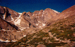
Longs Peak is one of Colorado's most famous peaks. Longs Peak,
at 14,255ft (4345m) is known as the Climbers Mountain, a fact
only proven considering the number of routes to the summit. Longs
Peak is visible for miles on the front range, and has been used
as everything from a navigational landmark to a test gauge for
predicting river levels.
Maps:
Major Trails:
 Longs Peak Trail:
- This is the most hiked trail in the park, and for good
reason. The trail leads to some of the most spectacular
scenery Colorado has to offer, not to mention some of the
highest peaks Colorado has to offer. Thousands have hiked
this trail to the summit of the Park's only 14,000+ foot
peak, Longs Peak. One half mile from the trailhead, the
trail forks. The left fork climbs Longs Peak, the right
fork climbs Storm Pass. A second trail, originating in
Tahosa Valley, meets the Storm Pass trail near Moore
Park. Back on the Longs Peak Trail, another left fork
atop Mills Moraine leads to Chasm Lake, while the right
fork leads to the summit.
- From this trail you can climb the following mountains: Battle Mountain, Estes Cone, Mount Lady Washington, Longs Peak, Mount Meeker, Storm Peak.
- From this trail you can visit the following: Alpine Brook, Boulderfield, Chasm Lake, Chasm View, Columbine Falls, The Diamond (East Face of Longs),
The Dove, Eugenia Mine, Granite Pass, Jims Grove, The Keyhole, Lambs Slide, The Loft, Mills Glacier, Mills Moraine, Moore Park, The Notch, Peacock Pool, Ships Prow, Storm Pass, The Trough.
Twin Sisters Trail:
- This trail originates in Tahosa Valley, and climbs the
Twin Sisters Peaks on the eastern edge of the park. The
climb offers some of the best views of Longs Peak, as
well as the front range.
- From this trail you can climb the following mountains: Twin Sisters Peaks.
- From this trail you can visit the following: Butterfly Burn, The Crags, Lookout Springs.
Questions? Comments? Contributions? Email
Us!
Maintained By Arthur Vyn Boennighausen